Updated 8 Apr 2009
|
WIRKSWORTH Parish Records 1600-1900
|
|
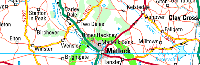
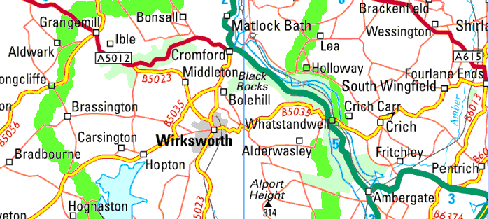
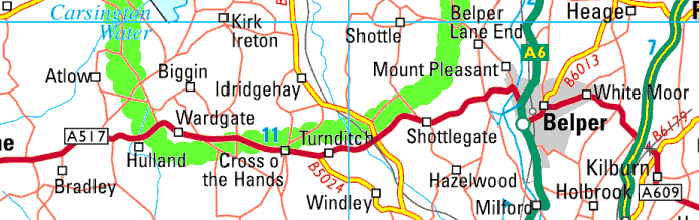
Map of Wirksworth Area
|

|
Here is a modern map to show the places in the "Wirksworth Area".
This is roughly the
area of the old Wirksworth parish in the 17th Century, with the town
of Matlock added. In later centuries Wirksworth parish decreased
in area as parts were given their own Parish status to cope with
increasing population.
Census districts for 1841-1891 have been
chosen to cover the same area.
Check the Parish Register List to see
the Parish Registers held at the Derbyshire Record Office at Matlock.
|
 |
|
Geograph to Google Earth conversions.
If you have (free) Google Earth installed:
Copy Lat/Long, paste into search box.
See the centre of the km square from space!
|
Geograph |
Google Earth |
square |
Latitude/Longitude |
------ | ------------------- |
SK2446 | 53.015247 -1.636261 |
SK2546 | 53.015200 -1.621355 |
SK2646 | 53.015152 -1.606450 |
SK2746 | 53.015102 -1.591545 |
SK2846 | 53.015050 -1.576640 |
------ | ------------------- |
SK2447 | 53.024236 -1.636185 |
SK2547 | 53.024189 -1.621277 |
SK2647 | 53.024141 -1.606368 |
SK2747 | 53.024091 -1.591460 |
SK2847 | 53.024039 -1.576552 |
SK2947 | 53.023985 -1.561644 |
SK3047 | 53.023929 -1.546735 |
SK3147 | 53.023871 -1.531827 |
------ | ------------------- |
SK2448 | 53.033225 -1.636110 |
SK2548 | 53.033178 -1.621198 |
SK2648 | 53.033130 -1.606287 |
SK2748 | 53.033080 -1.591375 |
SK2848 | 53.033028 -1.576464 |
SK2948 | 53.032974 -1.561552 |
SK3048 | 53.032918 -1.546641 |
SK3148 | 53.032860 -1.531730 |
SK3248 | 53.032800 -1.516819 |
------ | ------------------- |
SK2349 | 53.042214 -1.636034 |
SK2449 | 53.042214 -1.636034 |
SK2549 | 53.042167 -1.621119 |
SK2649 | 53.042119 -1.606205 |
SK2749 | 53.042069 -1.591290 |
SK2849 | 53.042016 -1.576376 |
|
|
Geograph |
Google Earth |
square |
Latitude/Longitude |
SK2949 | 53.041962 -1.561461 |
SK3049 | 53.041906 -1.546547 |
SK3149 | 53.041849 -1.531633 |
SK3249 | 53.041789 -1.516718 |
------ | ------------------- |
SK2350 | 53.051247 -1.650876 |
SK2450 | 53.051203 -1.635958 |
SK2550 | 53.051156 -1.621041 |
SK2650 | 53.051108 -1.606123 |
SK2750 | 53.051057 -1.591205 |
SK2850 | 53.051005 -1.576288 |
SK2950 | 53.050951 -1.561370 |
SK3050 | 53.050895 -1.546453 |
SK3150 | 53.050838 -1.531535 |
SK3250 | 53.050778 -1.516618 |
------ | ------------------- |
SK2451 | 53.060192 -1.635883 |
SK2551 | 53.060145 -1.620962 |
SK2651 | 53.060097 -1.606041 |
SK2751 | 53.060046 -1.591120 |
SK2851 | 53.059994 -1.576199 |
SK2951 | 53.059940 -1.561279 |
SK3051 | 53.059884 -1.546358 |
SK3151 | 53.059826 -1.531438 |
SK3251 | 53.059767 -1.516517 |
SK3351 | 53.059705 -1.501597 |
------ | ------------------- |
SK2352 | 53.069225 -1.650731 |
SK2452 | 53.069180 -1.635807 |
SK2552 | 53.069134 -1.620883 |
SK2652 | 53.069085 -1.605959 |
SK2752 | 53.069035 -1.591035 |
|
|
Geograph |
Google Earth |
square |
Latitude/Longitude |
SK2852 | 53.068983 -1.576111 |
SK2952 | 53.068929 -1.561188 |
SK3052 | 53.068873 -1.546264 |
SK3152 | 53.068815 -1.531340 |
SK3252 | 53.068755 -1.516417 |
SK3352 | 53.068694 -1.501493 |
------ | ------------------- |
SK2253 | 53.078257 -1.665585 |
SK2353 | 53.078214 -1.650658 |
SK2453 | 53.078169 -1.635731 |
SK2553 | 53.078123 -1.620804 |
SK2653 | 53.078074 -1.605877 |
SK2753 | 53.078024 -1.590950 |
SK2853 | 53.077972 -1.576023 |
SK2953 | 53.077918 -1.561096 |
SK3053 | 53.077862 -1.546169 |
SK3153 | 53.077804 -1.531243 |
SK3253 | 53.077744 -1.516316 |
------ | ------------------- |
SK2254 | 53.087246 -1.665516 |
SK2354 | 53.087203 -1.650585 |
SK2454 | 53.087158 -1.635655 |
SK2554 | 53.087112 -1.620725 |
SK2654 | 53.087063 -1.605795 |
SK2754 | 53.087013 -1.590865 |
SK2854 | 53.086960 -1.575935 |
SK2954 | 53.086906 -1.561005 |
SK3054 | 53.086850 -1.546075 |
SK3154 | 53.086793 -1.531145 |
SK3254 | 53.086733 -1.516215 |
SK3354 | 53.086671 -1.501285 |
------ | ------------------- |
|
|
Geograph |
Google Earth |
square |
Latitude/Longitude |
SK2255 | 53.096235 -1.665446 |
SK2355 | 53.096192 -1.650513 |
SK2455 | 53.096147 -1.635579 |
SK2555 | 53.096100 -1.620646 |
SK2655 | 53.096052 -1.605713 |
SK2755 | 53.096001 -1.590780 |
SK2855 | 53.095949 -1.575846 |
SK2955 | 53.095895 -1.560913 |
SK3055 | 53.095839 -1.545980 |
SK3155 | 53.095781 -1.531047 |
SK3255 | 53.095722 -1.516114 |
SK3355 | 53.095660 -1.501182 |
------ | ------------------- |
SK2356 | 53.105181 -1.650440 |
SK2456 | 53.105136 -1.635503 |
SK2556 | 53.105089 -1.620567 |
SK2656 | 53.105041 -1.605631 |
SK2756 | 53.104990 -1.590694 |
SK2856 | 53.104938 -1.575758 |
SK2956 | 53.104884 -1.560822 |
SK3056 | 53.104828 -1.545886 |
SK3156 | 53.104770 -1.530950 |
SK3256 | 53.104710 -1.516014 |
------ | ------------------- |
SK2357 | 53.114169 -1.650367 |
SK2457 | 53.114125 -1.635427 |
SK2557 | 53.114078 -1.620488 |
SK2657 | 53.114029 -1.605548 |
SK2757 | 53.113979 -1.590609 |
SK2857 | 53.113927 -1.575670 |
SK2957 | 53.113873 -1.560730 |
SK3057 | 53.113817 -1.545791 |
|
|
Geograph |
Google Earth |
square |
Latitude/Longitude |
SK3157 | 53.113759 -1.530852 |
SK3257 | 53.113699 -1.515913 |
------ | ------------------- |
SK2358 | 53.123158 -1.650294 |
SK2458 | 53.123113 -1.635351 |
SK2558 | 53.123067 -1.620409 |
SK2658 | 53.123018 -1.605466 |
SK2758 | 53.122968 -1.590524 |
SK2858 | 53.122916 -1.575581 |
SK2958 | 53.122861 -1.560639 |
SK3058 | 53.122805 -1.545696 |
SK3158 | 53.122747 -1.530754 |
SK3258 | 53.122688 -1.515812 |
------ | ------------------- |
SK2759 | 53.131957 -1.590438 |
SK2859 | 53.131904 -1.575493 |
SK2959 | 53.131850 -1.560547 |
SK3059 | 53.131794 -1.545602 |
SK3159 | 53.131736 -1.530656 |
------ | ------------------- |
SK2860 | 53.140893 -1.575404 |
SK2960 | 53.140839 -1.560456 |
SK3060 | 53.140783 -1.545507 |
SK3160 | 53.140725 -1.530558 |
SK3260 | 53.140665 -1.515610 |
------ | ------------------- |
SK2861 | 53.149882 -1.575316 |
SK2961 | 53.149827 -1.560364 |
SK3061 | 53.149771 -1.545412 |
SK3161 | 53.149713 -1.530460 |
------ | ------------------- |
| 143 1-km squares |
|
|
Convert any OS grid ref to Lat/Long..
Go to Nearby.org.uk.
Select Coordinate Convertor.
Enter the OS grid ref.
Get the Lat/Long.
|
Compiled, formatted, hyperlinked, encoded,
and copyright © 2009,
 All Rights Reserved.
|