Updated 14 Dec 2015
|
WIRKSWORTH Parish Records 1600-1900
|
|
Land owned by Philip GELL of Hopton Hall
around 1790 and let to various tenant farmers.
Much of this land has since been flooded by
Carsington Water since 1970.
|
The records described below, obtained in pdf format
on CD from Derbyshire Record Office, have been transcribed
and traced by the author and may contain errors. The land
was owned by Philip Gell of Hopton Hall, and let to various
tenant farmers. Dates appear to be "Late 18th cent and 1798",
and the records contain field names, areas, value per acre
and charge to the tenant. Around 1990 much of the land was
flooded to create Carsington Water reservoir, and many of the
fields were lost under the water. The single piece of folded
foolscap is numbered side 1 (inside) and side 2 (outside).
Three sketch maps of two of the farms have been traced and are
included.
|
This record is held by Derbyshire Record Office
Reference: D258/20/30/6-15
Description: Surveys and valuation of farms and lands in Carsington,
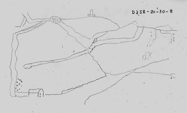
Hopton, Kirk Ireton and places not specified. D258/20/30/8
(of John Heayes' land) is endorsed with sketch plan and
account dated 1793. Includes a sketch map of Messrs
Heayes' farm (D258/28/8/10)
Date: Late 18th cent and 1798
Held by: Derbyshire Record Office, not available at The National
Archives
Language: English
|
(Side 2)
Wm Reigns Survey & Valuation John Steeple now Wm Reigns
(Side 1)
A Survey and valuation of John Steeple Farm
the property of P.Gell esq taken Nov 16 1792 by Geo Bestwick
Annual
Value
Names of Closes A R P per acre Ł s d
Longstone Fields 26 0 10 C D 13 0 7
Moor End 50 1 10 C U 30 3 9
Moor End 47 0 03 C U 6d 29 7 8
--------- --------
TOTAL 123 1 23 72 12 1
Ł s d
Annual Value 72 12 1
Deduct for Roads 2 12 1
---------
Annual Rent 70 0 0 with the 100 sheep grasses
upon Brassington moor
|
(Side 1 & 2)
A Survey and Valuation of Mr Fox's Farm
                                     Value Total
                            Quantity per   Value
                            A  R  P  Acre  L  s  d
House, Folds &c             0  2  00  --    -----
Orchard                     1  2  30  b d  3  7  6
Barn Yards                  1  0  10  b e  2  7  9
A part of Bacon Croft       0  3  31  b e  2  2  5
Hard Meadow                 2  3  22  u d  2 17  9
Sheen Croft                 3  1  14  m e  5 16  9
Deep Croft                  4  3  06  m e  8  7  6
Hob Torr                    4  0  20  m e  7  4  4
Hey Heads                   2  0  00  m d  3  0  0
Green Cliff                 6  0  07  m d  9  1  3
New Close                   4  0  15  m d  6  2  9
Art Houses                  5  2  00  u a  7 14  0
Little half acres           2  3  00  u a  3 17  0
Long half acres             4  1  06  u a  6  0  0
Half acres                  3  2  30  m d  5 10  7
Heald                       4  0  20  m d  6  3  9
Hayward Stone               5  2  20  m d  8  8  9
Middle field                4  0  00  u r  5 14  0
Spencer closes              5  2  16  u d  5 12  0
Hill Top                    7  0  00  u m  8  1  0
Water furrows               7  3  30  u l 10 14  3
Bottom of Crown lands       2  3  30  u a  4  2  3
Short middle furlong        6  0  15  u d  6  1  7
Ivit Lowe                   7  2  20  u d  7 12  6
Great & little Crown lands 15  3  14  u e 19 15 11
Another middle field        4  1  27  u e  5 10  5
                            --------       --------
   Carried Forward        118  3  21     160 16  7
|
                                               Value Total
                                      Quantity per   Value
                                      A  r  p  acre  L  s  d
Brought Forward                     118  3  21     160 16  7
Lemnos Clouds                         5  3  10
Pringle                               0  3  16 u e   8  6  6
Gill Croft                            3  1  27 b u   7  3  7
Bridge Gate Pingle                    1  1  34 b u   3  1  5
Town End                              2  3  33 b u   6  4  2
Pingle                                0  2  38 b u   1 10 11
Over Dale Acres                       4  1  20 m e   7 13  1
Breach                                3  0  23 u e   3 18  7
First Field upon Callow               4  1  18 u c   4  1  7
   side deducted for
   waste 10 shillings
Second ditto                          4  1  02 c r   3  8  2
An Allottment upon Moor              33  3  10 c a  30  8  7
   about 4 acres in Hopton
A part of Rowe Lowe                  18  0  00 c r  14  0  0
Abated 8 shillings in do for waste
Dowstead Hills in Carsington          4  1  24 m e   7 14  0
18 Beast Gates upon Carsington Hill            m d  27  0  0
                                    ------------------------
Total quantity intended to be Lett  206  1  36     285  7  5
Taken from the Farm Well Meadows      8  3  00 u d   8 15  0
Third Field upon Callow side          5  1  32 c b   3 16  3
52 Sheep grasses in Griffe walk                      5  2  0
                                     -----------------------
Total Annual Value                   220 2  28     303  0  9
J Outram Lett the above Absolute for               207 15  0
                                     -----------------------
Less than the present valuation                     95  5  9
                                     -----------------------
|
(Side 1)
John HEAYES Tenant
Value
Homestead A r p per case Ł s d
bean Orchard 2 3 30 |
Leys adjoining 0 1 22 | 35 6 2 0
Top of Leys at the Rick yard 0 0 25 |
Iron? Lands 3 3 05 40 7 11 3
Woolow and Tang? 1 3 20 40 3 15 0
Another Woolow 1 2 06 40 3 1 6
Another Woolow 1 3 07 40 3 11 9
Stoney plantation deducted 4 1 14 35 7 11 9
Catt Clouds 4 3 30 35 8 12 9
A ditto 2 1 28 25 3 0 7
Peasant Lowe 1 2 04 35 2 13 4
Fine More Hill 2 2 18 24 3 2 8
Breech 2 2 12 30 3 17 3
Another Catt Cloude 3 3 14 30 5 15 1
Quick setts 0 3 35 |
Joe acre 1 3 04 | 24 5 3 7
Scots Clow and Button park 1 2 12 |
Moor pieces 6 0 00 18 5 8 0
Catt Clou under ye Cliffe 2 1 11 | 30 7 7 4
South of Catt Clou 2 2 15 |
Cliffe 11 1 10 | 10 1 0 16 8 4 0
Deduction for new Plantation 1 0 10 |
A piece under ye Cliffe near
Hopton Field above Gate 1 3 12 | 25 29 17 2
Hopton Field 22 0 10 |
Carsington Hill 8 Gates 30 12 0 0
1 Little House & small garden in Carsington 1 5 0
Burnswood Top 22 2 12 14 15 16 0
Hopkinson? pidas? 23 3 10 12 16 4 5
---------- ---------
130 1 39 160 10 11
(Side 2)
Mr HAYES Farm
 s d
May 12th To Thos Steeples on acct by self 10 6
1793 to poste
Danl Higton in full 9 0
Deborah Stafford 2 0
Alice Hews 2 0
Henry Lomas 4 0
Poste 1 0
Jas. Twigg at ?? 6 1/2 10 0
s d
May 12th To Thos Steeples on acct by self 10 6
1793 to poste
Danl Higton in full 9 0
Deborah Stafford 2 0
Alice Hews 2 0
Henry Lomas 4 0
Poste 1 0
Jas. Twigg at ?? 6 1/2 10 0
|
(Side 2)

Particulars & Value                Mr Pakeman of Sutton on the Hill
of Plants Farm in Carsington
& D Gregorys in Hopton             ?  Smith of Homebridge near Wirksworth
    Nov 6 1790
|
(Side 1)
Particular and value of Buildings and lands in Carsington
the Property of Philip Gell Esq in the Tenure of Edward Plant
                                    A  r  p         L  s  d
House Outhouses Fold Garden
   & Croft about                    1  0  0         3  0  0
Near Breedy Furlong                 8  0  0 at 28s 11  4  0
Far Breedey Furlong                 8  2 10 at 27s 11 11  1
Barn Close     |                    3  2 28
Purla? Pingle  |                    1  2 29 at 24s  6  8  6
Piece below the Barn |              1  2 27
Ridding              |              4  0 10 at 15s  4  6  0
Broughs Nether Field                4  1 13 at 28s  6  1  3
Nether Field                        8  1 27 at 30s 12 12  6
Bent Leys                           2  1 37 at 20s  2  9  7
Nether Rings Meadow                 4  1 10 at 15s  3  4  8
Upper Rings Meadow                  4  1  8 at 23s  4 18 11
Great Rings Meadow                  8  2 14 at 23s  6  8  6
Hade Acre                           1  0  0         0 12  0
Bent Leys Pingle                    1  0 16 at 20s  1  2  0
Bent leys                           2  1 32 at 16s  1 19  2
Bent Leys                           3  2 15 at 18s  3  4  8
A Piece laid into the above         0  2 16 at 10s  0  6  0
New Close                           3  1 25 at 30s  5  2  2
Ashmores Blake Butts                6  0 00 at 18s  5  8  0
Middle Blake Butts                  2  3 20 at 18s  2 11  9
Upper Far Blake Butts               1  2 34 at 25s  2  2  9
Nether Far Blake Butts              2  2  8 at 16s  2  0  9
Near Blake Butts adjoining the Lane 1  3 24 at 30s  1 17  0
Far ditto called the Six Lands      1  2 32 at 30s  2 11  0
Nether ditto called Signing Ford    3  1  5 at 28s  4 11 10
Near Nether ditto                   3  1 14 at 28s  4 10  5
Bottom below the Greves             0  3 16 at 17s  0 14  5
Warm Greaves                       14  1 24 at 21s 15  2  4
Milking Greave                     14  0 10 at 20s 14  1  3
Tough Lands                         7  1 38 at 35s 13  2  0
Hopton Moor piece                  26  0  0 at  7s  9  2  0
                                  ---------        --------
                                  159  1 19        163 9  6
Twenty and three fourths Beast Gates
upon Carsington Hill at 30s                         30 15 0
                                                   --------
                                                   194  4 6
This a mistake, there only turned out to be
Ten Beast gates & none of which were let
with the Farm to Pakeman
|
Value of buildings and Lands in Hopton the Property
of Philip Gell Esq in the Tenure of David Gregory

                      A  r  p           L  s  d
Upper Godber Close    7  0  29  at 14s  5  0  6
Nether Godber Close  11  1   4  at 15s  8  9  4
Barn etc                                1  0  0
Barn Close            9  2  16  at 15s  7  4  0
Sweet Hills           7  0  12  at 17s  6  0  3
Limekill Close        6  2  30  at 18s  6  0  4
Watering Meer Close   8  1  20  at 18s  7 11  7
Crow Flatt           16  0  16  at 22s 17  4  2
Crow Dale side        8  2  24  at 14s  6  1  1
Crow Dale            16  3  36  at 13s 11  1  8
Great Warren Close    6  2  36  at 11s  3 13 11
Little Warren Close   2  3  11  at 12s  1 13  9
                      --------         --------
                     101 2   2         81 10  4
|
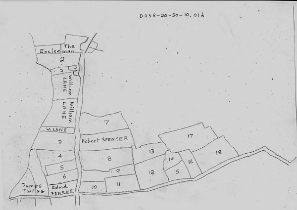
Messrs HEAYES Farm
D258-20-30-10.pdf 01a
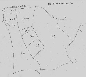 D258-20-30-10.pdf 01b
|
(Side 1)

Kirk Ireton  -  Ancient Estate

Edward Higgit                             Anth Blackwall (continued)
                                                               5  2  08
House Homestead & Croft  2  2  02   Brounts Croft              0  1  18
Thistley Close           5  1  12   Tenter Croft               0  1  38
Bridge Close             4  0  00   Well Bank                  0  1  32
Near Bottom              1  1  02   The Butts                  0  3  33
Lime Close               7  2  35   The Withys      school     0  3  00
Barn Close               3  2  12   Land mesne with Wirksworth 1  1  23
Another do               3  0  37   A land in round hill field 0  1  05
The Great Thorns         6  2  20   Another do                 0  3  00
The Far Bottom           2  1  24   The old Breck              3  0  03
The Little Thorns        2  3  16   Another do                 7  3  20
The old Breck            3  2  12   The school brook close     1  0  00
House Homestead & Croft             The school brook pringle   0  1  22
    in Town              0  0  10   The range bridge pingle    0  2  00
                         --------   The Drifts nooks           4  3  07
                        43  0  22   Another do                 8  1  00
                         --------   The linnah                13  1  15
                                    The Hasten Furlong         7  0  00
Anth Blackwall                      The Cross Gate             1  1  06
                                    The wean worthings         3  2  11
House Homestead & Croft  2  0  00   The New close              2  3  18
Hurst Lane               1  1  15   The Sears                  1  0  32
Tinkerley                0  3  08   Another do                 2  0  27
                                                               --------
Another Tinkerley        0  2  37          Carried forward    68  0  38
Dakins Hiusing & Croft   0  1  00
Housing & Yard near do   0  1  28
                         --------
    Carried forward      5  2  08
|
(Side 1)

Anth. Blackwall continued                John Blackwall continued
                             68  0  38                         33  0  14
The Earnscoast                2  0  00  The Cross Gate          2  0  33
The Gates                     1  3  27  The mow Slack           1  0  24
The Broadway                  7  1  27  The Schoolbrook meadow  1  0  23
The Slate Gutter              4  0  00  The Linnah             10  1  20
The Dakin Bolehill            4  0  32  Anv? do                11  3  18
The Bolehill                  0  3  30                         ---------
The Hurst Lane                1  2  15                         59  3  12
                             ---------                         ---------
                             98  1  09   The mesne wood or
                             ---------   Common piece          13  2  00
John Blackwall                           Edward Higgit         43  0  22
                                         Anth.Blackwall        98  1  09
Housing Homestead & Croft     1  0  00   John Blackwall        59  3  12
Tenter Croft                  0  1  30                         ---------
Well bank                     0  0  32          Total         214  3  03
The butts in round hill field 0  0  36                        ----------
Lands in round hill field     0  2  26
A land in Somer cliffe        0  0  25
The bolehill                  8  1  37
The limekiln Close            5  3  16
The top of Earnscoast         4  2  17
The new Close                 5  2  08
The Flatts                    1  3  20
The North field               4  0  07
                             ---------
    Carried Forward          33  0  14
|
(Side 1)
John Madkin Farm.  Kirk Ireton
                                                            A  r  p     L  s  d
                                                                        Annual Value
               House
Anth Blacwall  Yard & Croft                                 2  0  00
Do             House at bottom of Town 20s Land 7/6         0  1  00
               Brounts Croft, Flatt, & Tanter Croft         2  2  36
Ant Blackwall  Round the Field                              1  0  05
Do             Broadway, & Slate Gutter                    11  1  27
Do             Dakins Bolehill                              4  0  32
Do             The Five or Six Yates                        1  3  27
Do             New Close                                    2  3  18
Do             Wean Worthings                               3  2  11
Do             Cross Yate                                   1  1  06
Do             Hastin Furlong                               7  0  00
Do             Drift Nooks                                  8  1  00
Do             Another Do                                   4  3  07
               School brook Pingle                          0  1  20
Do             School brook Close                           1  0  00
John Blackwall A Land in Mesne Wall Carr or Well Bank
                 Let yearly for 5s per Year                20  0  32
A Blackwall    The Lands                                    0  3  00
                                                           ---------
               Total exclusive of ye Land Mesne Wall Carr  53  1  29     60  0  0


                    Lydia Johnson
                  House                                               20  1  0  0
John Blackwall Cross Yate                                   2  0  33
Do             Mow Slack                                    1  0  24      4  0  0
                                                            --------      --------
                          Total                             3  1  17      5  0  0
                                                            --------
                     John Ford Junr
J Blackwall    Bolehill                                     8  1  37
               Side Wood                                    1  3  32
J Blackwall    Earnscoat                                    4  2  17
                                                            --------
                          Total                            15  0  06     13  0  0
|
(Side 1)
                                                     Annual Value
Thos. Johnson                        A  r  p         L  s  d

     Hastin Furlong                  2  1  00
A.B. School Brook Pingle             0  1  22
J.B. School Brook Meadow             1  0  23
                                    ---------
                      Total          3  3  05        3  3  0
                                    ---------

             George Buxton
J.B. House & Croft                   1  0  00
     Well Bank                       0  0  32
     A Land in the Lands             0  1  00
     Scaws                           4  0  00
     Land in the Round Hill Field    0  2  26
     A Butt of Land                  0  0  36
     Broom stile                     4  0  00
     Broom                           5  0  00
     Tenter Croft                    0  1  30
     North field 4 0 7
       Pingle layed to it 2r         4  2  07
     New Close                       5  2  08
     Lime Kiln Close                 5  3  16
                                     --------
                       Total        31  2  35       37  0  0
                                    ---------
     A Land in Summer Cliffe         0  0  25
                                    ---------
                       Total        31  3  20
                                    =========

               John Dawson
     Benny Wales                     5  0  00        5  5   0
     Executors of the late Philip Dawson
     Lands in Open Fields            0  2  27        0  9   0
                                     --------
     Overseer of the Poor of Kirk Ireton
     An House late Henry Buxtons                     2  2   0
     Another House                                   0  19  6
|
(Side 2)
      Samuel Beardsley
                                            A  r  p      L  s  d
Edw Higgit  House & Croft at Kirk Ireton    0  0  10 now let to Kidd
            Lumb                            1  1  00
Edw Higgit  Heayes House & Croft            2  2  02
Do          Thistley Close                  5  1  12
Do          Bridge Close                    4  0  00
Do          Lime Close                      7  2  35
Do          Near Bottom                     1  1  02
Do          Far Bottom                      2  1  24
Do          Great Thorns                    6  2  20
Do          Little Thorns                   2  3  16
Do          Old Breck                       3  2  12
Do          Barn Close                      3  0  37
Wm Cockaine Turlo Field
Do          Do  with the footway, Hognaston 6  3  00
            Little Bridge Close             2  3  16
            Barn Close                      3  2  12
                                           ---------
                                           61  1  28
                                           ---------

     John Ford (Blacksmith)

       Hurst lane pingle                    1  2  15

     The late Thos Johnsons Farm
     is now let to Sundry Tenants for      65 19   0
     Old Rent                              53  6   6
                                           ---------
                        Advance            12 13   6
                                           ---------

Kirk Ireton
Account of Farms


A Survey of
some Land in Kirk Ireton
but now of liitle or no use
|
(Side 1)
A Survey of John Blackwalls Farm
now in the Possession of Lydia Johnson
                                A  R  P
House and Croft                 1  0  0
Tenter Croft                    0  1  30
Well Bank                       0  0  32
Butts in Round hill Field       0  0  36
Lands in Round do do            0  2  26
A Land in Summer Cliffe in the
way to his North field Close    0  0  25
Lime Kiln Close                 5  3  16
Bole Hill                       8  1  37
North Field                     1  0  07
Linnah laying West             10  1  20
Linnah do East                 11  3  18
Flatts                          1  3  20
New Close                       5  2  08
Top of Earnscroft               4  2  17
Cross Gate                      2  0  33
Mow Slack                       1  0  24
School brook Meadow             1  0  23
                               ---------
                   Total       59  3  12

Edward Higgett Farm in the Possession
of S Beardsley
                                A  R  P
House and Croft                 0  0  10
Far Bottom                      2  1  24
Near Bottom                     1  1  02
Bridge Close                    4  0  00
Thisley Close                   5  1  12
Close adjoining to House        2  2  02
Barn Close                      3  2  12
Neither Barn do                 3  0  37
Lime Close                      7  2  35
Great Thorns                    6  2  20
Little do                       2  3  16
Old Breck                       3  2  12
                               ---------
                 Total         43  0  22
|
(Side 1)
Anthony Blackwall Farm in
the Possession of
                             A  R  P
Hurst Lane                   1  1  15
Tinkerley                    0  3  08
Do                           0  2  37
Housing and Croft of Dakins  0  1  00
Housing and Yard             0  1  28
Brounts Croft                0  1  18
Tenter Croft                 0  1  38
Well Bank                    0  1  32
Butts                        0  3  33
Withy's                      0  3  00
Lands in a Close with
   Wiksworth school          1  1  23
A Land in Round hill field   0  1  05
A Land in Round do           0  3  00
Hurst Lane                   1  2  15
House and Croft              2  0  00
Wean Worthings               3  2  11
New Close                    2  3  18
Sears                        1  0  32
Do                           2  0  27
5 or 6 Gates or Yates        1  3  27
Earnscoast                   2  0  00
Broad way                    7  1  27
Slate Gutter                 4  0  00
Bole Hill                    4  0  32
Do  do                       8  3  30
Cross Yate                   1  1  08
Old Breck                    7  3  20
Old do                       3  0  03
School brook Close           1  0  00
School brook Pingle          0  1  22
Haston Furlong               7  0  00
Drift  Nook                  8  1  00
Drift do                     4  3  07
Linnah                      13  1  15
Range Bridge near the Linnah 0  2  00
                            ---------
                Total       98  1  09
|
(Side 1)
John Fords Farm
                        A  R  P
Linneys                 11  0  34
Linneys                 11  3  20
Croft and Homestead      4  1  20
Nether Field             3  3  15
Do  Do                   3  2  01
Cow Pasture              4  3  32
Long Close               3  3  35
Round Hill               2  0  35
Benny Walls              1  3  30
Linney Park              0  1  20
                        ---------
              Total     18  1  02

Mary Dane's Land
                         A  R  P
School Brook             1  0  29
Benny Walls              2  1  13
Hathorn Hill             3  3  11
Wain Worthing            5  2  13
Hurst lane Pingle        2  1  18
Kerchief                 0  2  33
                        ---------
            Total       15  3  37
In Side Wood - entire    2  2  00
                        ---------
                        18  1  37

                         A  R  P              L  s  d
Bole Hills               8  1  37  at  20/    8  9  7
Side Wood                1  3  32  at  13/    1  5  4
Earnscoat                4  2  17  at  15/    3  9  1
                        ---------             -------
               Total    15  0  06            13  4  0
                                             --------
|
(Side 2)
A Survey of Land at Kirk Ireton
|
(Side 1)
Geo Buxtons farm at Kirk Ireton
                                   L  s   d
Homestead and Croft                3  12  0
Well bank                              2  4
Land in the Lands                      5  0
Scaws                              4   0  0
Land in the Round hill field          13  3
Abat of Land                           4  6
Broom Stile                        3   0  0
Broom                              4  10  0
Tenner Croft                          11  4
North field                        6   5  0
New Close                          7  12  8
Lime Kiln Close                    6   8  8
                                  ---------
                                  37  12  10
              Deducted                12  10
                                  ----------
John Fords land                   37   0  0

                                   L   s  d
Bolehill                           8   9  7
Earnscote                          3   9  1
Sidewood                           1   5  4
                                   --------
 Let Absolute for 13L per acre    13   4  0

                                   L   s  d
Thos Johnson Haste? & furlong      2  10  7
Scoolbrooks                           14  6
                                   --------
                                   3   5  1

Lydia Johnson Croft gate and
Moore Slack                        4   0  0
House                              1   0  0
                                  ---------
                 Absolute          5   0  0
                                  ---------

     John Dawson                   5   5  0

Philip Dawson  2r  27p  in
open field at 18s per Acre
|
(Side 2)
John Smith
Terrior
|
(Side 1)
John Smith Tenant

A piece of Land in Hangar Hill or Cote field Gap laying   a  r  p          L  s  d
near Bolehill                                             0  3  22  at 25  1  2  2

Waterhole Barley Flatts                                   1  2  29
             Waste deduct                                    2  29
                                                          --------
             clear land                                   1  0  00  at 30  1  10  0

Tetlow                                                    2  1  24  at 30  3  15  0

          under Middleton Intake
Sourn? in to lay to Stephen Hall                          3  0  14  at 20  3   1  9
                                                                           --------
                                                                           9   8  11
(following appear to be scribbles)
|
----Anyone with more details for publication on this webpage,
please email  ---- ----
---------------
------------------------------
|
|
Find this Map Guide at
http://www.belper-research.com/records_matlock/Maps%20Holdings.pdf
DERBYSHIRE MAPS:
SUMMARY GUIDE
This is a quick research aid to manuscript maps held in collections in Derbyshire
Record Office. Entries are arranged by place. Further details are given in
catalogues available for reference in Derbyshire Record Office Search Room. These
should be checked before requests are made for documents to be consulted.
Where places were not subject to tithe and therefore no Tithe Map was created, this
is noted. Please also note that copyright restrictions may apply to maps in this list
and that it may not be possible to supply copies of outsize or fragile maps.
|
From Derbyshire Record Office, 12dec2015
Dear John,
Thanks for your email. Tithe maps were drawn up under the Tithe Commission for England and Wales, so they don't feature in private archives such as Gell. Each township or parish had its own, so if for instance you looked at the Carsington tithe map (dated 1839) and award (1838) you would probably find a good deal of it belonged to the Gells. Tithe maps are handy in that respect, because they do include field names - however, they work parish by parish, and the information is contained not on the map but on the award, so it would be quite a lot of work. On the plus side, tithe awards are arranged alphabetically by owner, so you would just have to find the "Gell" section and copy that. If you wanted our staff to do so on your behalf, that would be fine - we would need to know which parishes/townships you wanted us to check, and you would need to pay for as many half-hour chunks of staff time as you think appropriate - when the time ran out, we would let you have the results up to that point. Probably the most efficient way of communicating the information to you would be for us to scan the relevant sections of each award from microfilm. If it was your intention to reproduce those images online or in print, we ask you to let us know about that intention early on so we can establish the charges for that.
To order some research, please go to www.derbyshire.gov.uk/recordoffice and click "our services" then "research service".
Yours,
Mark (Smith)
|
Selected maps from under and around Carsington Water

-------------------------------------------------
Bonsall Parliamentary Enclosure Plan 1776 (Q/RI 19)
Bonsall Leys and Green Parliamentary Enclosure Plan 1776 (Q/RI 20)
Bonsall Leys and Green Parliamentary Enclosure Plan 1776 ( D71/1)
Bonsall Tithe Map 1848 (Tla) xxxxxxxxxxxxxxxxxxxxxxxxxxxxxxxxxxxxxxxxxxxxxx
Bonsall Township c1800 (D433/3/1)
-------------------------------------------------
Brassington Hoe Grange 18th cent (D749/12/32)
Brassington copy Parliamentary Enclosure Plan (1808) (Q/RIc 6)
Brassington Parish map c1850 (D1297A/PI) xxxxxxxxxxxxxxxxxxxxxxxxxxxxxx
(Brassington: no tithes payable, therefore no Tithe Map)
-------------------------------------------------
Callow Parliamentary Enclosure Plan (copy) 1807 (Q/RIc 44)
Callow p. Wirksworth Tithe Map 1844 (D2360/3/117a) xxxxxxxxxxxxxxxxxxxxxxxxxxxx
--------------------------------------------------
Carsington Aqueduct late 20th cent (D5719)
Carsington Tithe Map 1839 (D2360/3/182a) xxxxxxxxxxxxxxxxxxxxxxxxxxxxxxxxxxxxxx
Carsington Parliamentary Enclosure Award and Plan, Carsington Hill 1831 (Q/RI 27)
Carsington sketch maps 1709 (D258/18/6)
Carsington village and closes 17th cent (D258/22/11)
Carsington Pasture 1665 (D258/35/25)
---------------------------------------------------
Hognaston rough estate plan 1709 (D258/35/33/1)
Hognaston Old Field 1732 (D258/41/32)
Hognaston Wynn Parliamentary Enclosure Plan 1774 (Q/RI 52)
Hognaston Thompson estate c1832 (D97/19)
Hognaston Tithe Map 1846 (D2360/3/205a) xxxxxxxxxxxxxxxxxxxxxxxxxxxxxxxxxxxxxxxx
Hognaston Township 1864 (D4738)
----------------------------------------------------
Hopton Sketch plan of houses and crofts. 17th cent (D258/20/27/1)
Hopton Mr Stufing's house 1684 (D258/41/28/1)
Hopton village and other lands 1680s (D258/41/28/2)
Hopton Rough plan of Hopton 1709 (D258/48/26)
Hopton Tithe Map 1846 (D3105A/PI 18/1) xxxxxxxxxxxxxxxxxxxxxxxxxxxxxxxxxxxxxxxxxxxxx
Hopton Plan of siding, tramway & sand pits 1892 (D504/40/18/3)
-------------------------------------------------------
Ible Wood enclosure 1827 (D504/2/16/4)
Ible p. Wirksworth Tithe Map c1849 (D2360/3/210a) xxxxxxxxxxxxxxxxxxxxxxxxxxxxxxxxxxxx
-------------------------------------------------------------------
Kirk Ireton Estate, rough sketch maps 1709 (D258/35/33/9)
Kirk Ireton copy Parliamentary Enclosure Map 1807 (Q/RIc 44)
Kirk Ireton Tithe Map 1848 (D2360/3/46a) xxxxxxxxxxxxxxxxxxxxxxxxxxxxxxxxxxxxxxxxxxxxx
----------------------------------------------------
Wirksworth Notes and rough draft map 1709 (D258/18/6)
Wirksworth Meadow Farm, house and barn c1709 (D258/35/26/2)
Wirksworth township 1709 (D258 M/18/6)
Wirksworth copy plan of Gell estate 1710 (D1892 Z/Z 1)
Wirksworth copy plan of roads between Rowsley Bridge and Wirksworth Moor 1759 (D371/1)
Wirksworth Wigwall Grange rights, privileges and boundaries (18th cent) (D369 G)
Wirksworth town centre and Bolehill area (19th century tracing of late 18th century map) (D161)
Wirksworth Parliamentary Enclosure Plan 1806 (Q/RI 107)
Wirksworth Etwall Corporation estate1806 (D769 B/P 16)
Wirksworth Estate 1811 (D769 B/P 21)
Wirksworth Cromford and High Peak Railway:Steeple House to Hopton 1825 (D258/41/22/9)
Wirksworth Land and lead veins in the Hollow and part of Middleton and Cromford 1826 (D282 Z/PI)
Wirksworth copy plan of Gell estate 1826 (D504 B/LP 17, 18) xxxxxxxxxxxxxxxxxxxxxxxxxxxxxx
Wirksworth Tithe Map 1837 (D2223 A/PI 32) xxxxxxxxxxxxxxxxxxxxxxxxxxxxxxxxxxxxxxxxxxxxxxx
Wirksworth Tithe Map 1849 (D2360/3/12a)
Wirksworth Tithe Map (copy) (1849) (D4996/6/18)
Wirksworth land on Derby Road 1889 (D5282/25)
------------------------------------------------------
|
|
Compiled, formatted, hyperlinked, encoded,
and copyright © 2015,
All Rights Reserved.
|