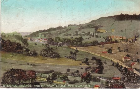
Posted 1923, entitled: Steeple Grange and "Barrow Ledge"
Undated.
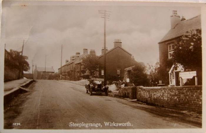
Posted 1908, entitled: "Steeple Grange, Wirksworth".
Stuart Flint writes:
re The photograph 475 Steepelgrange. It is not a church tower but a
chimney on the site of Black Rocks which once had a quarry ....The
remains of the gritstone building foundations once part of the site
where the chimney once stood are still to be seen.. I will look in my
records to find out what the chimney stack was used for. It may have
been a lead smelting plant or part of Bolehill Quarry..I have the
information somewhere.. The building in the photgraph standing on the
background appearing to stand in the centre of the road was The Railway
Inn now part of a farmhouse which was built alongside the Cromford &
High Peak Railway at Steeplehouse Arch.. My Gr Gr Grandfather Samuel
Flint when Station Master and Coal Merchant and his cousin Joseph Flint
Wharfinger lived near The Railway Inn at Flint's Wharf Steeplegrange
which was near the chimney...
I will get back to you as soon as possible
Regards Stuart G Flint.


Stuart Flint writes again:
The chimney is part of the site where the shaft for Cromford Moor
Mines is. The chimney is still to be seen only half the height as in
your photograph.. Many years ago during the mines heyday, there was a
large building covering the mine, the chimney stack part of that
building, so it was either an engine winding shed or possibly a
smelting mill
Regards Stuart G Flint.
Stuart Flint writes again:
Peter Naylor has contacted me and confirms my belief that the chimney
was part of Cromford Moor Mine the shaft at the side of the chimney
stack..He also confirms that the mine was still producing lead ore in
1908 when the photograph was taken and that the Chimney served both to
drive the winding engine and also possibly used as a flue of a smelting
mill.. Godbeheres Founder Mine was part of the system..Cromford Moor
Mines created some great wealth over the years..Peter is seeing
Mr Reiuwerts another author of lead mining books on Sunday and will
seek more information for me..
Regards Stuart G Flint
Steeple Grange and Barrell Ledge,
Wirksworth
This postcard has been marked with a "X" in the right hand edge.
Presumably this was the location of 88 Bolehill, which in the
1901 Census is shown as a 4-room house
at the junction of Oakerthorpe Rd and Sough Lane.
Wirksworth
The straight road running diagonally is probably Cromford Lane, with Oakerthorpe Road running by the "X"
The author finds the hill has always been called "Barrell", not "Barrow" Edge.
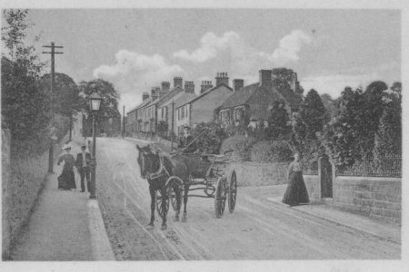
The postcard reads:
Addressed to: Mrs Jennings, 8 Regent St, Walsall, Staffs.
Addressed from: 88, Bole Hill, Wirksworth, Deryshire.
You will be surprised to know that I am having tea with Mrs Bird
& Ethel at Wirksworth. Ethel is settled here most comfortably & she
only wishes you could come & see her mother & herself. Has not forgotten
your or M.Aran kindness. Wish love to all, M.Quigley.
[see card 134 to same addressee].
This view shows a fine horse and trap, driven by a teenager. On the
left a young couple, the lady with an exotic big white hat, blouse
and skirt to the ground, the gentleman with straw boater and cane.
On the right a middle-aged lady, also with skirt to the ground.
A line of three cottages and three houses and a side road to the right
(opposite the gas lamp). Three telephone poles are visible,
at the junction in the distance, three larger houses, one of which is
the Railway Inn, run by the Howsley family (See Census:
1901,
1891,
1881,
1871,
1861,
1851 and
1841)
Through the trees on the right is a chimney.
"The chimney is part of the site where the shaft for Cromford Moor
Mines is. The remains of the gritstone building foundations, once
part of the site where the chimney once stood, are still to be seen..
[ref Stuart Flint's letters on left].
The road is probably today's Oakerthorpe Rd, though more research is
needed to establish the exact location.
The postcard reads:
Addressed to: Mr & Mrs Freshwater, Wood End Cottage, Cromford,
Nr Matlock Bath, Derbyshire.
Addressed from: -
Message: signed Ethel
Anyone with closer knowledge of the area, please contact:
Taken 2007 byKeith Repton
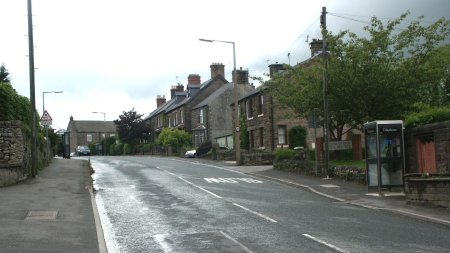
"Find attached a picture of the view as it is today the position of
Sough Lane is about 1200 yards south of this photo, the road in the
photo is at the top of Steeple Grange just before you drop down the
hill into Cromford village , as for the chimney in the background of
your photo it does not seem to be in the right alignment for the
leadworks so I will check on my OS map of 1897, it seems to be where
there used to be a brick works so I will have to get back to you on
that issue."
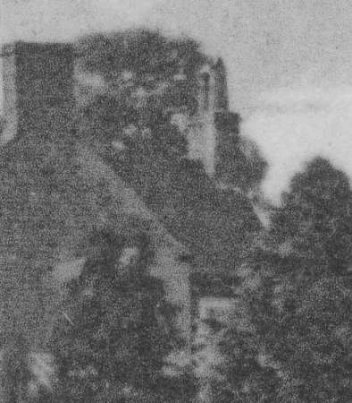
Enlargement:
The chimmey through the trees, part of Cromford Moor Mines.
Dates:
Photo taken:
Size:
Source:

Click on photo for enlargement (on CD only)
Have any more information about this photo?
Please e-mail the author on:
Click on photo for enlargement (on CD only)
Have any more information about this photo?
Please e-mail the author on: